Saint Barthélemy
 Flag
Flag
Saint Barthélemy (French: Saint-Barthélemy, French pronunciation: [sɛ̃baʁtelemi]), officially the Territorial collectivity of Saint Barthélemy (French: Collectivité territoriale de Saint-Barthélemy), is an overseas collectivity of France. Often abbreviated to Saint-Barth in French, or St. Bart’s or St. Barth’s in English, the indigenous people called the island Ouanalao. St. Barts lies about 35 km (21.75 mi) southeast of Saint Martin, and north of St. Kitts. Puerto Rico is 240 km (149.1 mi) to its west in the Greater Antilles.
The collectivity is one of four territories among the Leeward Islands in the northeastern Caribbean that comprise the French West Indies, along with Saint Martin, Guadeloupe (200 km southeast) and Martinique. Saint Barthélemy was for many years a French commune forming part of Guadeloupe, which is an overseas région and département of France and is therefore in the European Union.
Saint Barthélemy, a volcanic island fully encircled by shallow reefs, has an area of 22.1 km² (8.5 mi²) and a population of 8,902 (Jan. 2009 census). Its capital isGustavia, which also contains the main harbour to the island. It is the only Caribbean island which was a Swedish colony for any significant length of time; Guadeloupe was under Swedish rule only briefly, at the end of the Napoleonic Wars. Symbolism from the Swedish national arms, the Three Crowns, still appears in the island’s coat of arms. The language, cuisine and culture, however, are distinctlyFrench. The island is a popular tourist destination during the winter holiday season, especially the rich and famous during the Christmas and New Year period.
History
 Coastline of St. Barts – 17th century
The first European colonisation of the island began in 1623 with the arrival of settlers from Dieppe.
18th century

Historical quartiers (1801)
There was a very brief takeover by the British in 1758. The island was given to Sweden in 1784 in exchange for trade rights in Gothenburg. It was only after 1784, when King Louis XVI exchanged the island to Sweden, that the island’s fortunes changed for the better. This change of control saw progress and prosperity as the Swedes declared Gustavia a free port, convenient for trading by the Europeans for goods, including contraband material.
19th Century
Slavery was practiced in St. Barts under the “Ordinance concerning the Police of Slaves and free Coloured People” of 1787. The last legally owned slaves in the Swedish colony of St. Barts were granted their freedom by the state on 9 October 1847. Since the island was not a plantation area, the freed slave suffered economic hardships due to lack of opportunities for employment.
In 1852, a devastating hurricane hit the island and this was followed by a fire. Following a referendum in 1877, Sweden gave the island back to France in 1878, after which it was administered as part of Guadeloupe.
20th Century
On 19 March 1946, the people of the island became French citizens with full rights.
Many men from St. Barts took jobs on St Thomas in order to support their families. The island received electricity circa 1961. Tourism began in the 1960s, developed in the 1970s, and led to considerable international popularity beginning in the 1980s. Today the island is known for its exclusivity and posh tourism.
21st Century
Saint Barthélemy was for many years a French commune forming part of Guadeloupe, which is an overseas région and département of France and is therefore in the European Union. Through a referendum in 2003, island residents sought separation from the administrative jurisdiction of Guadeloupe, and it was finally accomplished in 2007. The island of Saint Barthélemy became an Overseas Collectivity (COM). A governing territorial council was elected for its administration, which has provided the island with a certain degree of autonomy. The Hotel de Ville, which was the town hall, is now the Hotel de la Collectivité. A senator represents the island in Paris. St. Barts has retained its free port status.
Geography

Map showing location of Saint Barts relative to Sint Maarten/Saint Martin and St Kitts

A map of Saint-Barthélemy
Located approximately 250 kilometres (160 mi) east of Puerto Rico and the nearer Virgin Islands, St. Barts lies immediately southeast of the islands of Saint Martin and Anguilla. It is separated from Saint Martin by the Saint-Barthélemy Channel. It lies northeast of Saba and St Eustatius, and north of St Kitts. Some small satellite islets belong to St. Barts including Île Chevreau (Île Bonhomme), Île Frégate, Île Toc Vers, Île Tortue and Gros Îlets (Îlots Syndare). A much bigger islet, Île Fourchue, lies on the north of the island, in the Saint-Barthélemy Channel. Other rocky islets which include Coco, the Roques (or little Turtle rocks), the Goat, and the Sugarloaf.
Marine Areas
St. Barts forms, with St. Martin, Anguilla, and Dog Island, a distinct group that lies upon the western edge of a flat bank of soundings composed chiefly of shells, sand, and coral. From St. Barts, the bank extends east-southeast, ending in a small tongue or spit. It is separated from the main bank by a narrow length of deep water. East of the island, the edge of the bank lies 22 km away.
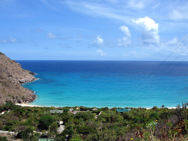
Grande Saline Bay provides temporary anchorage for small vessels while Colombier Bay, to the northwest, has a 4 fathoms patch near mid entrance. In the bight of St. Jean Bay there is a narrow cut through the reef. The north and east sides of the island are fringed, to a short distance from the shore, by a visible coral reef. Reefs are mostly in shallow waters and are clearly visible. The coastal areas abound with beaches and many of these have offshore reefs, some of which are part of a marine reserve.
The marine reserve, founded in 1999, covers more than 1,000 hectares (2,500 acres) of protected and vulnerable habitats, bays and islands, and includes a zone that is restricted to scientific observations only. As the sea surrounding the St. Barts is rich in coral reefs and other precious marine life, the area has been declared a protected area since 1996. Environmental awareness is quite pronounced in St. Barts and is promoted by the Environmental Commission.

A view of Gustavia.

Shell Beach (Anse De Grand Galet).
There are as many as 22 public beaches (most beaches on St Barthélémy are known as “Anse de…” etc. ) of which 15 are considered suitable for swimming. They are categorized and divided into two groups, the leeward side (calm waters protected by the island itself) and windward side (some of which are protected by hills and reefs). The windward beaches are popular for windsurfing. The beach of St Jean is suitable for water sports and facilities have been created for that purpose. The long beach at Lorient has shade and is a quiet beach as compared to St. Jean.
Grand-cul-de-sac is a long beach with facilities for water sports. Anse de Flamands is a very wide sandy beach and Le petit Anse (The little beach), just to the north of Anse de Flamands is very safe and popular with the locals for their children. Anse Toiny beach is in a remote location and is considered suitable for experienced surfers as the water current is very strong.
On the leeward side, the notable beaches are: Anse du Gouverneur, Anse du Colombier which is only accessible by foot or by boat, Anse de Grand Galet (Shell Beach) and Anse de Grande Saline which is popular with nudists. The area around the salt ponds near the Anse de Grande Saline beach is marshy and is a habitat for tropical birds. Ile islet, an offshoot of the leeward side, has a white sandy beach.
Shell Beach, also called Anse de Grand Galet (in French, ‘Anse’ means “panhandle” and Galet means “pebble”), is a beach in the southwestern part of Gustavia. A large number of sea shells are scattered on this beach. This beach was subject to the strong waves of hurricane Lenny in 1999, which resulted in erosion of the sand. This necessitated supplementing the beach with new sand in 2000.
On the north coast, on the far eastern side of the island, there are two lagoons called the Anse de Marigot and Anse du Grand Cul-de-Sac.

Turtle and Whale
Interior areas
Morne du Vitet, 286 m in height, is the highest peak in the island. There are few sheep pens built with stone walls on the slopes of the mountain. A hill road leads to the Grand Cul-de-Sac from where scenic views of the entire coast line can be witnessed. Hills and valleys of varying topography cover the rest of the island. Two other hills near the island’s east end are of nearly the same elevation at 262 and 250 m above sea level.
Populated Areas
The population is spread among 40 quartiers, roughly corresponding to settlements. They are grouped into two paroisses (parishes):
