Saint Helena, Ascension and Tristan da Cunha
Tristan da Cunha
Documentary about Tristan Da Cunha, one of the world’s most isolated islands, with a population of only 300 people. Its only contact with the outside world at the time was a once a year mail boat. American producer, John Hemingway travelled to the island on that boat and spent two weeks on the island. The film is a record of his journey and his experiences during his stay.
 Flag
Flag
Saint Helena, Ascension and Tristan da Cunha is a British Overseas Territoryin the southern Atlantic Ocean consisting of the island of Saint Helena, Ascension Island and the island group called Tristan da Cunha. It was previously known asSaint Helena and Dependencies until September 1, 2009, when a new constitution came into force giving the three islands equal status within the territory.
Administrative Divisions
Administratively, the territory is divided into the same three parts as the territory’s geography, namely Saint Helena, Ascension and Tristan da Cunha. Each is governed by a council. The Governor of the territory presides over the Saint Helena Legislative Council, while he or she is represented by an Administrator on Ascension Island and an Administrator on Tristan da Cunha that preside over these two areas’ Island Councils.
Of volcanic origin, the islands of Saint Helena, Ascension Island, and Tristan da Cunha were all formerly separate colonies of the English crown, though separately discovered by several Portuguese explorers between 1502 and 1504.
Portuguese Discovery
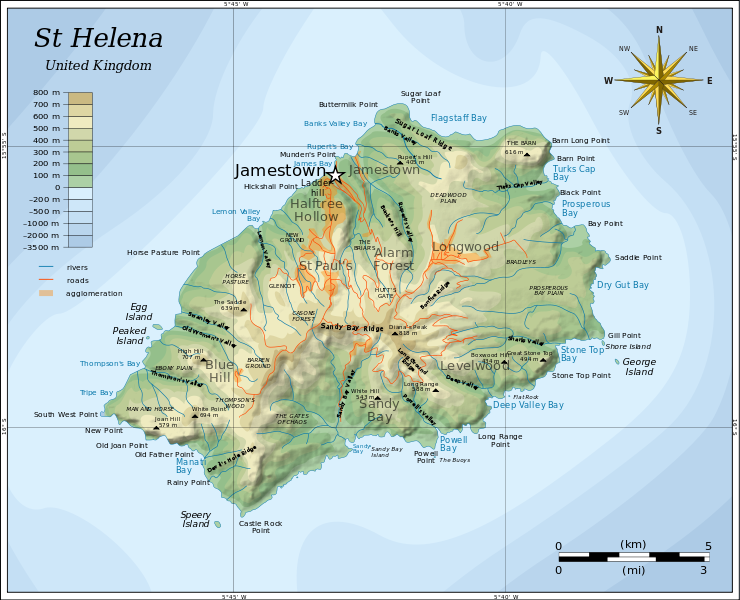 Map of Saint Helena.
The Portuguese found Saint Helena uninhabited, with an abundance of trees and freshwater. They imported livestock, fruit trees and vegetables, and built a chapel and one or two houses. Though they formed no permanent settlement, the island became crucially important for the collection of food and as a rendezvous point for homebound voyages from Asia. Englishman Sir Francis Drake very probably located the island on the final lap of his circumnavigation of the world (1577–1580). Further visits by other English explorers followed, and, once St Helena’s location was more widely known, English warships began to lie in wait in the area to attack Portuguese carracks on their way home from India. In developing their Far East trade, the Dutch also began to frequent the island and made a formal claim to it in 1633, but did not settle the isle and by 1651 largely abandoned it in favour of their colony at the Cape of Good Hope.
English and British Colonisation
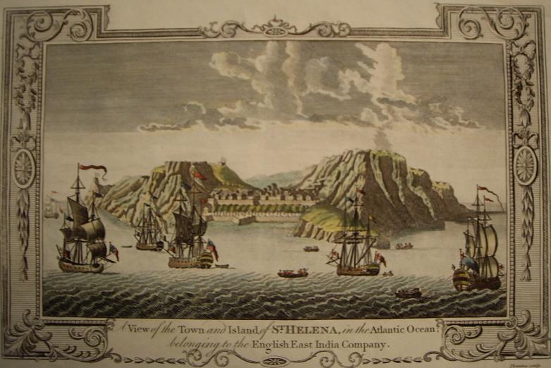 A View of the Town and Island of St Helena in the Atlantic Ocean belonging to the English East India Company (engraving c. 1790).
In 1657 the English East India Company was granted a charter to govern Saint Helena by Oliver Cromwell, and the following year the Company decided to fortify and colonise the island with planters. The first governor, Captain John Dutton, arrived in 1659, and it is from this date that St Helena claims to be Britain’s second oldest (remaining) colony (after Bermuda). A fort was completed and a number of houses were built. After the Restoration of the English monarchy in 1660, the East India Company received a Royal Charter giving it the sole right to fortify and colonise the island. The fort was renamed James Fort and the town Jamestown, in honour of the Duke of York and heir apparent, later King James II of England.
In subsequent geopolitical developments, all the islands eventually passed formally to the United Kingdom as the British Empire grew into a global great power,England having become part of the new Kingdom of Great Britain in 1707 and then the United Kingdom in 1801. The most important and first settled, the island of Saint Helena, had been governed by the East India Company since 1659. It became internationally known as the British government’s chosen place of exile of Napoleon Bonaparte, who was detained on the island from October 1815 until his death on May 5, 1821, and it was made a British crown colony in 1834 by the Government of India Act 1833. Unoccupied Ascension Island was garrisoned by the Royal Navy on October 22, 1815, shortly after which the end of the Age of Sail made its difficult location in the equatorial doldrums less important relative to its strategic importance as a centrally positioned naval coaling station. For similar reasons Tristan da Cunha was annexed as a dependency of the Cape Colony (British South Africa) on August 14, 1816, at the settlement of the Napoleonic wars. For a short period just prior, Tristan da Cunha had been inhabited by a private American expedition who named the territory the Islands of Refreshment.
The political union between these colonies began to take shape on September 12, 1922, when by letters patent Ascension Island became a dependency of Saint Helena. Lightly populated Tristan da Cunha, even today little more than an outpost with a population of less than three hundred, followed suit on January 12, 1938. The three island groups shared this constitutional relationship until September 1, 2009, when the dependencies were raised to equal status with St. Helena and the territory changed its name from “Saint Helena and Dependencies” to “Saint Helena, Ascension and Tristan da Cunha”.
World War II and Subsequent Military Presence
During the Battle of the Atlantic of World War II and the following several years of u-boat warfare in the Atlantic, both Saint Helena and Ascension Island were used by the Allies to base patrolling anti-surface-commerce-raider and anti-submarine warfare (ASW) forces against the Axis powers‘ naval units. Initially long range naval patrol flying boats were used in the effort, and later in the war during the struggle to improve air coverage over the commercially important sea lanes, air strips were built to support land based aircraft which supplied, augmented and complemented the PBY Catalina patrol planes in the vitally important ASW mission.
The United States and Great Britain still jointly operate the airfield (RAF Ascension Island) on Ascension, which also serves as a space-based communications, signals intelligence, and navigation nexus and hub (Ground station). One of only five GPS satellite ground stations is located there.
Geography
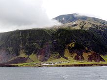 Edinburgh of the Seven Seas, Tristan da Cunha. Category:Geography of Saint Helena, Ascension and Tristan da Cunha and List of mountains and hills of Saint Helena, Ascension and Tristan da Cunha
The territory stretches across a huge distance of the South Atlantic Ocean with the northern-most island, Ascension, having a latitude of 7° 56′ S of the equator and the southern-most island, Gough Island, at 40° 19′ S. Between Saint Helena and Tristan da Cunha is the Tropic of Capricorn. The distance between the northern tip of Ascension Island and the southern tip of Gough Island is 2,263 miles (3,642 km) (an equivalent distance between London and the Dead Sea). The whole territory lies in the Western Hemisphere and has the same time zone: Greenwich Mean Time. Daylight saving timeis not observed.
Ascension has a warm, arid climate, whilst St Helena is more moderated (and arid near the coasts) and Tristan much cooler. The highest point of the territory is Queen Mary’s Peak on the island of Tristan da Cunha, with an elevation of 2,062 metres (6,765 ft) above sea level. The mountain is listed as an ultra prominent peak.
Although all three parts of the territory were formed by volcanic activity, only the Tristan da Cunha group of islands are volcanically active at the moment.
Territorial Waters

Tristan da Cunha on February 6, 2013, as seen from the International Space Station
The territorial waters of the islands extend out to 12 nautical miles (22 km) from their coastal baselines. The Exclusive Economic Zones(EEZs) extend 200 nautical miles (370 km) from the islands’ baselines. Despite their size, the three EEZs do not overlap or touch one another, nor do they reach the EEZs of any other country or territory. The territory has the largest EEZ of any of the British overseas territories (indeed larger than the United Kingdom’s) and if included in the ranking of countries by size of EEZ, the territory would be 21st, behind Portugal and ahead of the Philippines. Neither the islands nor their EEZs are the subject of any current international dispute.
http://en.wikipedia.org/wiki/Saint_Helena,_Ascension_and_Tristan_da_Cunha
