Early St. Lawrence County History
The largest of New York counties, St. Lawrence, located in the extreme north, has also the longest frontage on the St. Lawrence River. Because this stream was the scene of the first French explorations, the county has a history dating back to a time as early as any other part of the State. The Lachine Rapids stopped the larger vessels of the first explorers, but there is little doubt that they set foot on what is now county territory. Champlain, in his rovings, probably visited the region, but there is no doubt that Father Lallemant landed at what is now Ogdensburg in the spring of 1626 and gave the name of La Gallette to the place. Settlements were made here and elsewhere in the region, forts were erected, and the Jesuits attempted to win the hearts of the Indians.
The interest of the English was aroused by the French progress, and was one of the causes of the French and Indian War. The engagement of Isle Royal, ending with the surrender of the French, ended the reign of France in New York, 1763. The English promptly improved La Gallette, put a garrison there and changed the name to Oswegatchie, the name of the river tributary of the St. Lawrence. The new settlers began timber cutting and denuded great areas of land.
The Revolution in turn dethroned the English, and under American control colonization began in earnest. The same difficulties arose in regard to land titles that did so much to retard the development of the North Country. The Indians had rights; both French and English had given grants and leases; and now the State of New York began to sell great tracts. Ten townships of 64,000 acres were laid out on the south side of the St. Lawrence, and every inducement made to encourage their settlement. To clear title, the State took the stand that the Indians had the prior ownership, and since they had conveyed that to the State, any means necessary could be used to oust any not having a bill of sale from New York.
The growing settlements found it a great hardship to have to go long distances to transact legal affairs, so in March, 1801, a petition was sent to the Assembly asking that the ten townships might be made one town, with the name Lisbon, and annexed to Clinton County. This was granted, but now they had to go to Plattsburgh to attend court, so in the fall they petitioned for erection as a separate county, which was again granted, and St. Lawrence was formed March 3, 1802. The county now embraces an area of 2,701 square miles. Oswegatchie (Ogdensburg) was named the shiretown; an old barracks being the first county courthouse and jail.
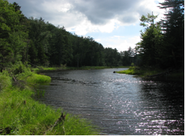
St. Lawrence County covers so great a territory that it has an infinite variety of surface ranging from the fertile bottom lands of the river to the timbered slopes of the Adirondacks. Lakes are numerous; Black Lake, one of the most picturesque, is some twenty miles long; Cranberry Lake, raised fifteen feet by a dam, furnishes important water power. In a survey made in 1892, there are forty-seven suitable places for the erection of dams in the county, ranging from six to 164 feet in height, with an average of eighteen feet. The principal rivers which drain the country are: The Oswegatchie, Indian, Grass, Raquette and St. Regis.
Fifty-six minerals are found in this hilly region, but of these only a few are of commercial value, such as lime, marble, talc, some of the lead combinations (Galena) and iron, the latter being of the bog varieties and not now utilized as it was in the early days. The water powers have encouraged manufacturing, although this has never been done on a large scale. The soil, with its special adaptation to grains, grazing and fruits, and the vast forests, has been the main source of the prosperity of the county. Its location on the St. Lawrence River, together with its many natural beauties, attracts large numbers of summer visitors.
The rivers, for two centuries, were the only means of transportation. Many impractical schemes were tried to clear navigation, or to canalize the streams, but these only led to failure. In the end it was the Canadian government which made up-stream passage of the great river possible. Steamboat navigation began with the building of the “Ontario,” in 1816. She was 110 feet long by 24 feet wide, driven by a single cylinder engine. Her speed seldom attained five miles and it took her ten days to make the trip from Ogdensburg to Lewiston, but she was received with great eclat and continued in service until 1832.
The opening of a State road, from the river to Albany, begun in 1808, with the establishment of a stage coach route from Canton to Plattsburg about the same time, gave some intercommunication, but it was not until railroads were built that this section of the State was connected with the rest of it and the other States. The first road was the “Northern,” from Ogdensburg to Rouse’s Point, on Lake Champlain, begun in 1848 and completed in two years. A north and south line was projected in 1852 from the New York Central, at Rome, to Cape Vincent on the St. Lawrence, to which a branch to Ogdensburg was built in 1862. These, with other branches, became a part of the New York Central in 1891.
