Clifton, NJ
From Wikipedia, the free encyclopedia
Clifton is a city in Passaic County, New Jersey, United States. As of the 2010 United States Census, the city had a total population of 84,136. The 2010 population represented an increase of 5,464 residents from its population of 78,672 in the 2000 Census, making it the state’s 11th largest municipality.
Clifton was incorporated as a city by an Act of the New Jersey Legislature on April 26, 1917, replacing Acquackanonk Township, based on the results of a referendum held two days earlier. Clifton is listed under five different zip codes (07011 Main Avenue, 07012 Allwood, 07013, 07014 Delawanna and 07015).
Clifton is located at 40°52′04″N 74°09′16″W / 40.867899°N 74.154520°W / (40.867899, -74.154520).Geography
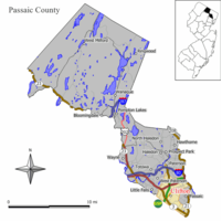
According to the United States Census Bureau, the city has a total area of 11.4 square miles (29.5 km2), of which, 11.3 square miles (29.3 km2) of it is land and 0.1 square miles (0.3 km2) of it (0.88%) is water.
Clifton is located 10 miles west of New York City off both Route 3 and Route 46. The city is also served by the Garden State Parkway, Route 19 and Route 21.
DemographicsAs of the census of 2000, there were 78,672 people, 30,244 households, and 20,354 families residing in the city. The population density was 6,965.2 people per square mile (2,688.1/km2). There were 31,060 housing units at an average density of 2,749.9 per square mile (1,061.3/km2). The racial makeup of the city was 66.22% White, 2.89% African American, 0.24% Native American, 6.44% Asian, 0.03% Pacific Islander, 9.60% from other races, and 4.57% from two or more races. Hispanic or Latino of any race were 19.84% of the population.
There were 30,244 households out of which 28.9% had children under the age of 18 living with them, 51.3% were married couples living together, 11.5% had a female householder with no husband present, and 32.7% were non-families. 27.9% of all households were made up of individuals and 13.7% had someone living alone who was 65 years of age or older. The average household size was 2.59 and the average family size was 3.20.
In the city the population was 21.6% under the age of 18, 7.7% from 18 to 24, 30.7% from 25 to 44, 22.5% from 45 to 64, and 17.6% who were 65 years of age or older. The median age was 39 years. For every 100 females there were 91.4 males. For every 100 females age 18 and over, there were 88.1 males.
The median income for a household in the city was $50,619, and the median income for a family was $60,688. Males had a median income of $40,143 versus $32,090 for females. The per capita income for the city was $23,638. About 4.3% of families and 6.3% of the population were below the poverty line, including 8.6% of those under age 18 and 5.2% of that age 65 or over.
The largest ancestry groups in Clifton are Italian American (17%), Polish American (13%), Irish American (9%) and German American (8%). Many Turkish, Albanian, and Ukrainian immigrants also live in Clifton. There are significant populations of Hispanics, Arabs, Filipinos, Chinese, and Indians as well.

Seal

Census Bureau map of Clifton, New Jersey
Coordinates: 40°52′4″N 74°9′16″W / 40.86778°N 74.15444°W / Coordinates: 40°52′4″N 74°9′16″W / 40.86778°N 74.15444°W /
