Aruba

Aruba: History
Aruba’s path to the present day is marked by the mystery of ochre-colored rock drawings left behind by island shamans, the enterprising spirit of European adventurers and settlers and the diverse experiences and traditions brought by the many nationalities that have since sought out the island as either a new home or temporary resting place. The look of the people, the languages they speak and the innate hospitality that manifests itself in the Aruban psyche is the result of a multi-cultural mix that reflects a rich past.
Flag Aruba (/əˈruːbə/ ə-roo-bə; Dutch pronunciation: [aˈruba]) is a 33 kilometre long (20 mi) island of the Lesser Antilles in the southern Caribbean Sea, located 27 km (17 mi) north of the coast of Venezuela. Together with Bonaire and Curaçao, it forms a group referred to as the ABC islands of the Leeward Antilles, the southern island chain of the Lesser Antilles. Collectively, Aruba and the other Dutch islands in the Antilles are commonly referred to as the Netherlands Antilles or the Dutch Antilles. Furthermore, Aruba is one of the four constituent countries that form the Kingdom of the Netherlands, along with the Netherlands, Curaçao and Sint Maarten. The citizens of these countries all share a single nationality: Dutch. Aruba has no administrative subdivisions, but, for census purposes, is divided into eight regions. Its capital is Oranjestad. Unlike much of the Caribbean region, Aruba has a dry climate and an arid, cactus-strewn landscape. This climate has helped tourism as visitors to the island can reliably expect warm, sunny weather. It has a land area of 179 square kilometres (69.1 sq mi) and is densely populated, with a total of 101,484 inhabitants at the 2010 Census. It lies outside the hurricane belt.
Aruba’s first inhabitants are thought to have been Caquetíos Amerinds from the Arawak tribe, who migrated there from Venezuela to escape attacks by the Caribs. Fragments of the earliest known Indian settlements date back to 1000 AD. As sea currents made canoe travel to other Caribbean islands difficult, thus Caquetio culture remained more closely associated with that of mainland South America.
 The capital Oranjestad
Europeans first learned of Aruba following the explorations for Spain by Amerigo Vespucci and Alonso de Ojeda in the summer of 1499. Though Vespucci boasted of discovering the island, Ojeda was likely first, learning of it from natives of nearby islands. Both described Aruba as an “island of giants”, remarking on the comparatively large stature of the native Caquetíos compared to Europeans. Ojeda also referred to the island as Oro Hubo, Spanish for “It had gold”. Gold was not discovered on Aruba, however, for another 300 years. Vespucci returned to Spain with stocks of cotton and brazilwood from the island and described houses built into the ocean. Vespucci and Ojeda’s tales spurred interest in Aruba, and Spaniards soon colonized the island. Because it had low rainfall, Aruba was not considered profitable for the plantation system and the economics of the slave trade.
Aruba was colonized by Spain for over a century. Simas, the Cacique or chief in Aruba, welcomed the first Catholic priests in Aruba, who gave him a wooden cross as a gift. In 1508, the Spanish Crown appointed Alonso de Ojeda as its first Governor of Aruba, as part of Nueva Andalucía. Arawaks spoke the “broken Spanish” which their ancestors had learned on Hispaniola. Another governor appointed by Spain was Juan Martínez de Ampiés. A cédula real decreed in November 1525 gave Ampíes, factor of Española, the right to repopulate Aruba. In 1528, Ampíes was replaced by a representative of the House of Welser. The Netherlands have covered the island with their regulations since 1629. Since 1636, Aruba has been under Dutch administration, initially governed by Peter Stuyvesant, later appointed to New Amsterdam (New York City). Stuyvesant was on a special mission in Aruba in November and December 1642. The island was included under the Dutch Dutch West India Company (W.I.C.) administration, as “New Netherland and Curaçao,” from 1648 to 1664. In 1667 the Dutch administration appointed an Irishman as “Commandeur” in Aruba. The Dutch took control 135 years after the Spanish, leaving the Arawaks to farm and graze livestock, and used the island as a source of meat for other Dutch possessions in the Caribbean. In August 1806, General Francisco de Miranda and a group of 200 freedom fighters, traveling to liberate Venezuela from Spain, stayed in Aruba for several weeks. In 1933, Aruba sent its first petition to the Queen seeking independent status and autonomy. During World War II, Aruba was one of the main suppliers of refined petroleum products to the Allies.
During the war, after the German occupation of the Netherlands, Aruba was made a British protectorate from 1940 to 1942, and a US protectorate from 1942 to 1945. On 16 February 1942, a German submarine (U-156) under the command of Werner Hartenstein attacked the island’s oil processing refinery, but the mission failed. In March 1944, Eleanor Roosevelt, the First Lady of the United States, briefly visited American troops stationed in Aruba. In attendance were Curaçao Governor P. Kasteel, and U.S. Rear Admiral T. E. Chandler.
Move towards Independence
In August 1947, Aruba presented its first Staatsreglement (constitution), for Aruba’s status aparte as an autonomous state within the Kingdom of the Netherlands. By 1954, the Charter of the Kingdom of the Netherlands was established, providing a framework for relations between Aruba and the rest of the Kingdom. In 1972, at a conference in Suriname, Betico Croes (MEP), a politician from Aruba, proposed a sui-generis Dutch Commonwealth of four states: Aruba, the Netherlands, Suriname and the Netherlands Antilles, each to have its own nationality. C. Yarzagaray, a parliamentary member representing the AVP political party, proposed a referendum so that the people of Aruba could choose whether they wanted total independence or Status Aparte as a full autonomous state under the Crown. Croes worked in Aruba to inform and prepare the people of Aruba for independence. In 1976, he appointed a committee that chose the national flag and anthem, introducing them as symbols of Aruba’s sovereignty and independence. He set 1981 as a target date for independence. In March 1977, the first Referendum for Self Determination was held with the support of the United Nations; 82% of the participants voted for independence. The Island Government of Aruba assigned the Institute of Social Studies in The Hague to prepare a study for independence; it was titled Aruba en Onafhankelijkheid, achtergronden, modaliteiten en mogelijkheden; een rapport in eerste aanleg (Aruba and independence, backgrounds, modalities and opportunities; a preliminary report) (1978).
At the conference in The Hague in 1981, Aruba’s independence was set for the year 1991. In March 1983, Aruba reached an official agreement within the Kingdom for its independence, to be developed in a series of steps as the Crown granted increasing autonomy. In August 1985 Aruba drafted a constitution that was unanimously approved. On 1 January 1986, after elections were held for its first parliament, Aruba seceded from the Netherlands Antilles; it officially became a country of the Kingdom of the Netherlands. Full independence was projected in 1996. After his death in 1986, Croes was proclaimed Libertador di Aruba. At a convention in The Hague in 1990, at the request of Aruba’s Prime Minister, the governments of Aruba, the Netherlands, and the Netherlands Antilles postponed indefinitely its transition to full independence. The article scheduling Aruba’s complete independence was rescinded in 1995, although the process could be revived after another referendum.
Geography 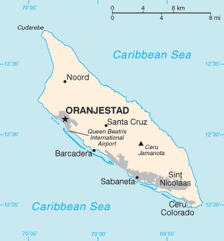 Geography of Aruba
Aruba is a generally flat, riverless island in the Leeward Antilles island arc of the Lesser Antilles in the southern part of the Caribbean. It has white sandy beaches on the western and southern coasts of the island, relatively sheltered from fierce ocean currents. This is where most tourist development has occurred. The northern and eastern coasts, lacking this protection, are considerably more battered by the sea and have been left largely untouched by humans. The hinterland of the island features some rolling hills, the best known of which are called Hooiberg at 165 meters (541 ft) and Mount Jamanota, the highest on the island at 188 meters (617 ft) above sea level. Oranjestad, the capital, is located at 12°19′N 70°1′W. To the east of Aruba are Bonaire and Curaçao, two island territories which once formed the southwest part of the Netherlands Antilles. This group of islands is sometimes called the ABC islands. The Natural Bridge was a large, naturally formed limestone bridge on the island’s north shore. It was a popular tourist destination until its collapse in 2005.
-
 Baby natural bridge in Aruba
 -
 Natural bridge in Aruba (collapsed 2 September 2005)


