Early Putnam County History
Lying on the east shore of the Hudson River, between Westchester and Dutchess counties, is Putnam County. This section embraces nearly all of the Highlands east of the river; has an area of 234 square miles: is one of the scenic regions noted for its variety of hills, valley and lake, and through which are scattered the estates and homes of many of the wealthy of New York City. The mountains of this region are of the abrupt rocky sort, with deep narrow valleys, of which the best known are: Peekskill Hollow, Canopus and Pleasant. The Croton River reaches into the county and in the valleys is numerous picturesque lakes, among which the most notable and largest are: Mahopac, nine miles in circumference; Canopus, two miles by one; Gleneida, with an area of 170 acres and 130 feet deep.
There are a number of minerals of minor value in the hills of this district, but none of them are utilized to any great extent. Nor has agriculture or manufacturing ever been followed in any large way. The most of the land in Putnam is incapable of being brought under the plow, but there are a number of fertile areas which have been cultivated since the founding of the first settlements in the county. Dairying takes the lead in agriculture. Milk, the main product, is shipped out over the railroads which tap the region.
During the Revolution the mountains, or rather the passes through them, were considered of high strategic value and carefully guarded. Many large bodies of troops were stationed among the hills, with General Putnam as the commander-in-chief of the forces the most of the time. This latter fact was the reason for the naming of the county after him, when it was set off from Dutchess June 12, 1812. One of the several points fortified was Martlear’s, or Constitution Island, in 1775, and from which, 1778, a huge chain was stretched across the river to West Point. This chain was 1,500 feet long with links weighing 125 pounds. Although of no service during the conflict, it at least held together, which was more than could be said of the greater one placed across the stream from Anthony’s Nose to Fort Montgomery two years earlier.
It seems strange that the county was not named after the owner of the greater part of the land out of which it was formed. Probably the name Philipse was in disrepute when the county was formed in 1812, because of the litigation started by John Jacob Astor and others, and the worry which had been borne by the purchasers of pieces of the property previous to this time. The Highland patent granted to Adolph Philipse June 17, 1679, who died without issue in 1749, willed it to his nephew Frederick Philipse. The latter’s decease brought the land into the hands of his four children, Philip, Susannah, Mary and Margaret.
The territory concerned not only covered Putnam County, except that portion known as the “Gore,” to the north, and the “Oblong,” a strip forming the west (sic)* border of Putnam, but a part of Dutchess as well. At the time of the Revolution, the heirs to the patent had been attainted, and their lands confiscated by the Commissioners of Forfeiture. But as a third of the estate was vested in the children of Col. Roger Morris and, therefore, not legally open to seizure, the State had to come to the rescue of the small purchasers of this particular part of the patent lands by settling with the Morris heirs.
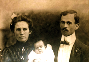
Picture:
Nora Letie Pittman (1881-1973) & Jasper Newton DeRossette (1879-1967)
with their daughter, DeSala Elizabeth DeRossette (1903-1980)
Jasper Newton was the son of Nancy Elizabeth DeRossette (1857-1931)
This information may not under any conditions be sold or used in a commercial project without expressed prior written permission. The entire contents of the Putnam County Photographs are copyright 1998, 2001 by Charles A. Reeves, Jr.
