Nebraska
The Lure of the Land – a Nebraska Story
The Homestead Act triggered one of the largest migrations in history for “free land” on the Great Plains. Photographs tell the story of African-American homesteaders in Nebraska. For more Nebraska Stories, visit http://www.netnebaska.org/nebraskskastories.
 Timeline of Nebraska: 1500’s – 1600’s
- (1541) Explorers claimed Nebraska for Spain
- (1682) French explorer Robert Cavelier claimed Nebraska for France
1800’s
- (1803) U.S. acquired Nebraska from France in the Louisiana Purchase
- (1804) Lewis and Clark traveled up the Missouri River
- (1819) U.S. Army established Fort Atkinson, Nebraska’s first military post
- (1823) First permanent white settlement built at Bellevue
- (1833) U.S. government purchased the Pawnee Indian lands, south of the Platte River
- (1840s) Settlers by the tens of thousands traveled across the state, following the Oregon Trail
 (1854) Nebraska Territory organized
- (1862) The Homestead Act encouraged new settlers from the east into Nebraska
- (1867) Nebraska became a state
- (1868) Lincoln replaced Omaha as the state capitol
- (1877) The famed Indian warrior Crazy Horse surrendered, along with 1,000 of his followers near Camp Robinson. He was later killed
- (1898) The Mississippi International Exposition opened in Omaha


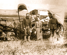
Homesteaders in central Nebraska in 1886
The history of the U.S. state of Nebraska dates back to its formation as a territory by the Kansas-Nebraska Act, passed by theUnited States Congress on May 30, 1854. The Nebraska Territorywas settled extensively under the Homestead Act during the 1860s, and in 1867 was admitted to the Union as the 37th U.S. state.
Pleistocene

During the last ice age, continental ice sheets repeatedly covered eastern Nebraska. The exact timing that these glaciations occurred remain uncertain. Likely, they occurred between two million to 600,000 years ago. During the last two million years, the climate alternated betweencold and warm phases, respectively called “glacial” and “interglacial” periods instead of a continuous ice age.[4] Clayey tills and large boulders, called “glacial erratics“, were left on the hillsides during the period when ice sheets covered eastern Nebraska two or three times. During various periods of the remainder of the Pleistocene and into the Holocene, the glacial drift was buried by silty, wind-blown sediment called “loess“.
Holocene (present-day)
As the climate became drier grassy plains appeared, rivers began to cut their present valleys, and present Nebraska topography was formed. Animals appearing during this period remain in the state to this day.
European exploration: 1682–1853
 Crow Dog Horse of the Omahas
Several explorers from across Europe explored the lands that became Nebraska. In 1682, René-Robert Cavelier, Sieur de La Salle claimed the area first when he named all the territory drained by the Mississippi River and its tributaries for France, naming it the Louisiana Territory. In 1714, Etienne de Bourgmont traveled from the mouth of the Missouri River in Missouri to the mouth of the Platte River, which he called the Nebraskier River, becoming the first person to approximate the state’s name.
In 1720, Spaniard Pedro de Villasur led an overland expedition that followed an Indian trail from Santa Fe to Nebraska. In a battle with the Pawnee, Villasur and 34 members of his party were killed near the juncture of the Loup and Platte Rivers just south of present-day Columbus, Nebraska. Marking a major defeat for Spanish control of the region, a monk was the only survivor from the party, apparently left alive as a warning to the colony of New Spain. With the goal of reaching Sante Fe by water, the pair of French-Canadian explorers named Pierre and Paul Mallet reached the mouth of what they named the Platte River in 1739. They ended up following the south fork of the Platte into Colorado.
In 1762, by the Treaty of Fontainebleau after France’s defeat by Great Britain in the Seven Years War, France ceded its lands west of the Mississippi River to Spain, causing the future Nebraska to fall under the rule of New Spain, based in Mexico and the Southwest. In 1795 Jacques D’Eglise traveled the Missouri River Valley on behalf of the Spanish crown. Searching for the elusive Northwest Passage, D’Eglise did not go any further than central North Dakota.
Early settlements
In 1794 Jean-Baptiste Truteau established a trading post 30 miles up the Niobrara River. A Scotsman named John McKay established a trading post on the west bank of the Missouri River in 1795. The post called Fort Charles was located south of present-day Dakota City, Nebraska.
In 1803 the United States purchased the Louisiana Territory from France for $15,000,000. What became Nebraska was under the “rule” of the United States for the first time. In 1812 President James Madison signed a bill creating the Missouri Territory, including the present-day state of Nebraska. Manuel Lisa, a Spanish fur trader from New Orleans, built a trading post called Fort Lisa in thePonca Hills in 1812. His effort befriending local tribes is credited with thwarting British influence in the area during the War of 1812.
The U.S. Army established Fort Atkinson near today’s Fort Calhoun in 1820 in order to protect the area’s burgeoning fur trade industry. In 1822 the Missouri Fur Company built a headquarters and trading post about nine miles north of the mouth of the Platte River and called it Bellevue, establishing the first town in Nebraska. In 1824 Jean-Pierre Cabanné established Cabanne’s Trading Post for John Jacob Astor‘s American Fur Company near Fort Lisa at the confluence of Ponca Creek and the Missouri River. It became a well-known post in the region.
In 1833 Moses P. Merill established a mission among the Otoe Indians. The Moses Merill Mission was sponsored by the Baptist Missionary Union. In 1842 John C. Frémont completed his exploration of the Platte River country with Kit Carson in Bellevue. He sold his mules and government wagons at auction in there. On this mapping trip, Frémont used the Otoe word Nebrathka to designate the Platte River. Platte is from the French word for “flat”, the translation of Ne-brath-ka, meaning “land of flat waters.”
1854–1867 Territorial period – Main article: Nebraska TerritoryFurther information: Nebraska Territorial Legislature
The Kansas-Nebraska Act of 1854 established the 40th parallel north as the dividing line between the territories of Kansas and Nebraska. As such, the original territorial boundaries of Nebraska were much larger than today; the territory was bounded on the west by the Continental Divide between the Pacific and Atlantic Oceans; on the north by the 49th parallel north (the boundary between the United States and Canada, and on the east by the White Earth and Missouri rivers. However, the creation of new territories by acts of Congress progressively reduced the size of Nebraska.
Most settlers were farmers, but another major economic activity involved support for travelers using the Platte River trails. The Missouri River towns became important terminals of an overland freighting business that carried goods brought up the river in steamboats over the plains to trading posts and Army forts in the mountains. Stagecoaches provided passenger, mail, and express service, and for a few months in 1860–1861 the famous Pony Express provided mail service.
Many wagon trains trekked through Nebraska on the way west. They were assisted by soldiers at Ft. Kearny and other Army forts guarding the Platte River Road between 1846 and 1869. Fort commanders assisted destitute civilians by providing them with food and other supplies while those who could afford it purchased supplies from post sutlers. Travelers also received medical care, had access to blacksmithing and carpentry services for a fee, and could rely on fort commanders to act as law enforcement officials. Forts Kearny also provided mail services and, by 1861, telegraph services. Moreover, soldiers facilitated travel by making improvements on roads, bridges, and ferries. The forts additionally gave rise to towns along the Platte River route.
The wagon trains gave way to railroad traffic as the Union Pacific Railroad–the first transcontinental railroad—was constructed west from Omaha through the Platte Valley. In 1867 Colorado was split off and Nebraska, reduced in size to its modern boundaries, was admitted to the Union.
Land changes
On February 28, 1861, Colorado Territory took portions of the territory south of 41° N and west of 102°03′ W (25° W of Washington, DC). On March 2, 1861, Dakota Territory took all of the portions of Nebraska Territory north of 43° N (the present-day Nebraska-South Dakota border), along with the portion of present-day Nebraska between the 43rd parallel north and the Keya Paha and Niobrara rivers (this land would be returned to Nebraska in 1882). The act creating the Dakota Territory also included provisions granting Nebraska small portions of Utah Territory and Washington Territory—present-day southwestern Wyoming, bounded by the 41st parallel north, the 43rd parallel north, and the Continental Divide. On March 3, 1863, Idaho Territory took everything west of 104°03′ W (27° W of Washington, DC).

Civil War – Main article: Nebraska in the American Civil War
Governor Alvin Saunders guided the territory during the American Civil War (1861–1865), as well as the first two years of the postbellum era. He worked with the territorial legislature to help define the borders of Nebraska, as well as to raise troops to serve in the Union Army. No battles were fought in the territory, but Nebraska raised three regiments of cavalry to help the war effort, and more than 3,000 men served in the military.
Capital changes
The capital of the Nebraska Territory was at Omaha. During the 1850s there were numerous unsuccessful attempts to move the capital to other locations, including Florence and Plattsmouth. In the Scriptown corruption scheme, ruled illegal by the United States Supreme Court in the case of Baker v. Morton, local businessmen tried to secure land in the Omaha area to give away to legislators. The capital remained at Omaha until 1867 when Nebraska gained statehood, at which time the capital was moved to Lincoln, which was called Lancaster at that point.
