Living in Chatham, NJ
(c. Chartham Historical Society, 2001)
HISTORY of Chartham, New Jersey
As the melting Wisconsin Glacier slowly retreated north 20,000 years ago, it left behind Lake Passaic in the curves of the Watchung Mountains. The land that is now Chatham was at the bottom of that lake, nearly 160 feet below the surface. The only visible sign of what would become Chatham was a long island formed by the top of the hill at Fairmount Avenue, known as Long Hill. Lake Passaic drained into the sea when the ice cap melted near Little Falls. The Passaic River slowly made its winding path through the marshlands.
Early Settlers
Six or seven thousand years ago the first people to settle in the area were the Lenni Lenape (Original People) Indians. It is believed that the Lenape migrated from Canada and possibly Siberia in search of a warmer climate. The Minsi group of Lenni Lenape occupied the northern section of New Jersey, including the area of present-day Chatham.
In early summer the Lenape journeyed to the sea to feast on clams and oysters. Traveling from the northwest, they followed a path along the Passaic River through the Short Hills to the New Jersey shore. The trail became known as the Minisink Trail and followed a route that includes what is now Main Street in Chatham.
The Lenni Lenape forded the Passaic River at a shallow point east of Chatham at a place they called the Crossing of the Fishawack in the Valley of the Great Watchung. Fishawack and Passaic are two versions of the many ways early settlers tried to spell the name they heard the Indians call the river.
In 1680 Sir George Carteret paid the Minsi the equivalent of $55 for land that included the present area of Chatham. By 1721 John Budd, a wealthy Philadelphia merchant, owned much of the land in the area. He sold some of his holdings in 1728 to John and Daniel Day, who became the first settlers on the west bank of the Passaic. John Day built a bridge over the Passaic roughly at the location of the present-day Route 124 bridge. The small village, called Days Bridge expanded along both sides of the river.
John Day established a tavern that became well-known among travelers. There were several miles south of the bridge and the village became a center for residents of outlying areas. People came to barter goods, have their grain ground, and lumber sawed. They visited the all-important blacksmith to have their horses shod and they went to church.
By 1750 the main street of Days Bridge stretched for three-quarters of a mile on either side of the river. Names associated with Chatham appear: Samuel Lum, Nathaniel Bonnell (also spelled Bonnel), and David Vanderpoel. These men settled in the area by the time of the Revolutionary War and made substantial contributions to Chathams early history.
The Revolutionary War
On November 23, 1773, the following notice appeared in the New York Journal or Advertiser:
Whereas the inhabitants of a certain village, situated at Passaic River, on the main road that leads from Elizabeth-Town to Morris-Town, found themselves under a considerable disadvantage from the places not having a particular name….the principal freeholders and inhabitants assembled together on Friday, the 19th inst., and unanimously agreed to call it Chatham.
The new name was chosen to honor the English Prime Minister, Sir William Pitt, and Earl of Chatham. Pitt was revered as a champion of the American colonies in their struggle with England because he opposed King George Ills tax policies. The name Chatham means a village of cottages, and the area was just that as the Revolutionary War began.
Chathams citizens proved to be staunch revolutionaries and joined with leaders from other villages to form committees of observation and correspondence. Chatham citizens erected a liberty pole at what is now the corner of Main Street and University Avenue.
Throughout the war Chatham was the scene of much troop movement. For two long winters Chatham served as a buffer between the British in Elizabethtown and the patriotic troops of General George Washington at Jockey Hollow near Morristown. In 1776 New Jersey bore the brunt of the war. Towns such as Chatham and Springfield were expected to hold against any enemy advance to the west.
With the outcome of the Revolution in doubt, Continental Army officials decided to create a newspaper dedicated solely to the patriots cause. In 1779 Shepard Kollock, an artillery soldier with a newspaper background, started the New Jersey Journal in Chatham. He continued to publish this weekly newspaper until 1783.
In late August 1781, Washington assembled his army of two or three thousand men in the Chatham area. The French army established a camp at Whippany at the same time. To give the appearance of a permanent encampment, Washington ordered the French to build their large bake ovens to the east of the village. He arranged other preparations to further the deception. Rumors began to spread that the combined forces planned to attack Sir Henry Clinton and the British in New York City.
However, Washingtons real intention became clear in the early morning hours of August 29. The army quietly left Chatham, heading south for Yorktown, Virginia. Clinton did not learn of their departure until the army had crossed the Delaware River. Washingtons maneuver helped force the surrender of Gen. Charles Cornwallis at Yorktown in October.
Growth During the Nineteenth Century
With the war ended, Chatham settled back into peaceful pursuits. The population grew, but the economic base of the town, which stretched west and south for considerable distance, remained the bridge and the mills along the river.
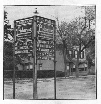
As people migrated westward, passenger and freight trade between the seaport area of Elizabeth and the western mountains increased. In 1801, New York investors interested in the lucrative western New Jersey market obtained a charter for the first state turnpike. The Morris Turnpike connected the west with Newark through the upper Delaware. Its first section ran from Elizabeth to Morristown through Springfield and Chatham. Toll gates stood near what is now Canoe Brook Country Club and near the Madison Junior High School. Soon farmers, unwilling to pay the toll or “shunning the pike, began traveling on a parallel route along what is today called the Shunpike Road (known as Watchung Avenue in Chatham Borough).
The Morris and Essex Railroad came to Chatham in 1837. The railroad was a wood-burning, two-locomotive line that ran from Newark through Orange to Morristown. With luck, it was possible to get to New York on business and return home the same day. Chatham gradually became a summer resort (people came for the fresh air) and commuter town, quite well established by the start of the Civil War with almost 3,000 citizens.
The introduction of the railroad helped encourage a thriving brick business that developed in 1835. Chatham also became a center of the rose growing industry in the 1870’s and 80’s. Louis M. Noe, who, with his two brothers-in-law, was the largest peach grower in New Jersey, built greenhouses for his specialty, the American Beauty Rose. Noes roses, with five foot stems, sold even in Europe.
In 1867, a wealthy industrialist, George Shepard Page, took Chatham by storm. He bought several hundred acres of land, including the Bonnell family mill sites on the Passaic River. He built a mansion on Hillside Avenue, known as Dixiedale. Page converted old mill sites to roofing paper factories and persuaded the Lackawanna Railroad to stop at his factories. He also convinced the U.S. Government that Stanley, as his land was known, needed a post office with G. S. Page as the first postmaster.
Industry attracted a good many Irish to Chatham and by 1870 Irish and other Catholics founded a mission and a school that was completed in 1872. In 1887 a church was built on the corner of Washington Avenue and Oliver Street. A new social dimension was given to the town by the addition of the Irish to Chathams population.
The years between the Civil War and World War I were a period of quiet living and simple pleasures. Chathams reputation as a fine, healthy place to live brought a community of bustling tourist trade. Advertisements of its pure mountain air appeared as far away as Boston. Many travelers visited the Fairview Hotel on Main Street, which flourished at the turn of the century.
The trains that brought vacationers to Chatham also transported residents to city jobs. The Chatham Accommodation left at 7:15 a.m. and returned at 6:00 p.m. When the Lackawanna electrified the railroad in 1930, surrounding communities delighted in and celebrated the new soot-free service.
MUNICIPAL GOVERNMENT
The government of Chatham evolved to reflect the growth of the area. Morris County had been carved out of Hunterdon County in 1738, due to increasing population in Hunterdon. In 1740, Morris County Courts convened and divided the county into three townships: Morris, Hanover, and Pequannock. The New Jersey Legislature created Chatham Township from parts of Morris, Hanover, Florham Park, Madison and Chatham.
When it was found that villages, which Chatham had become in 1892, had no power to establish public utilities, a group of citizens, led by village president Frederick Harvey Lum, persuaded the state legislature to pass a special act establishing the Borough of Chatham, which took effect on March 1, 1897. Under the Borough form of government, which Chatham Borough still maintains, there is a 6-member Borough Council, in which each Council Member is elected at-large and serves for a 3-year term. The mayor is elected separately and serves a 4-year term. The first public utility was the water department, in February 1898. This was followed by an electric department, in 1901 (which was subsequently sold to Jersey Central Power and Light).
The neighboring towns of Madison and Florham Park also seceded, leaving Chatham Township at its present geographic size. Chatham Township has maintained its committee form of government in which there are 5 Committee Members elected at-large, each for 3-year terms, and the Committee Members select one of their members to serve as mayor for a one-year term — since its founding in 1806.
CHATHAM TODAY
The character of Chatham Borough still reflects its early roots. The town grew as real estate developers purchased land and built homes for commuters in the early part of the 20th Century. Within the Boroughs 2.4 square miles, there are residential areas reflecting the wide range of housing styles popular in America in the late-nineteenth and early twentieth centuries, a charming central business district on Main Street, small retail centers on the east and west ends of Main Street, several garden apartment complexes, and small industrial areas on the periphery of the town. As of the 2010 census, the population of Chatham Borough is 8962. (The population of neighboring Chatham Township is 10,452.)
There are numerous annual events in which Chatham Borough celebrates and preserves its small town character, including the Fishing Derby at Kelleys Pond, the Fishawack Festival, the Fourth of July Parade, and the Green Fair. In addition, a Farmers Market operates at the Railroad Station from late June to mid-November, providing shoppers with the opportunity to buy New Jersey grown produce, locally-baked goods, meat and fish, and other foodstuffs.
John T. Cunningham, in his preface to Chatham: At the Crossing of the Fishawack, states “I doubt that any other community of Chathams size in this country has ever taken such a detailed look at its history. More information about the history of the Chathams can be found in the following books, available at the Library of the Chathams or the Chatham Historical Society.
Books
1. History of Chatham, New Jersey. Ambrose Ely Vanderpoel. 1959 Detailed, scholarly work, dwelling heavily on the War of Independence.
2. Chatham: At the Crossing of the Fishawack. John T. Cunningham. 1967. The story of Chatham from its beginnings through 1966.
3. Shepard Kollock: Editor for Freedom. John R. Anderson. 1975. The story of the New-Jersey Journal and its publisher in Chatham, 1779-83.
4. Village at War. Donald Wallace White. 1979. A story of the people of Chatham, New Jersey, at the time of the American Revolution.
5. Memories Entwined with Roses. Ruth Pierson Churchill. 1984.
Pamphlet
Washingtons Ruse de Guerre. Ambrose Ely Vanderpoel. Reprint of Chapter XVI of History of Chatham.
For more information: Chatham Historical Society
The Chatham Historical Society maintains an extensive photo collection. Many of the photos have been published in our books. Please enjoy viewing this gallery that includes samples from our books Images and Ten on a Toboggan.

The first trolley came to Chatham in 1912, after overcoming severe opposition in town. Trolleys ran east and west every half hours and took about thirty minutes longer than a train from Chatham to Newark. Long lineups of horses and wagons streamed through the freight yard on Bowers Lane in about 1900. The railroad brought in coal, dry goods, cloth, food and nearly everything needed by the town. It took out products from Chathams mills and greenhouses.
Main Street residents Mrs. William Ogden and her two daughters, Anna (left) and Nana, posed for a visiting photographer in 1905.

When this photo was taken around 1890, Hudson Mintons general store and post office on the corner of Long Hill Road (now Fairmount Avenue) and Main Street was a town social center. Erected about 1850, the store was eventually replaced by a bank.
This portion of South Passaic Avenue looked like a tree-shaded country village when this picture was taken in the 1890’s but it was only a few blocks from Chatham center.
A map drawn by Jimmy Littlejohn shortly before the start of World War I. Budd Lane (now Passaic Avenue) had been cut through and most lots on Main Street on both sides of the river were occupied.

Nineteenth-century Main Street in Chatham would turn to mud with even a light snowfall. This scene is just west of Fairmount Avenue. The fencing was erected early in the century to keep sheep and hops from invading local yards as they were driven toward Newark and Elizabeth markets.

Main Street, Chatham after a snowfall in the days just before World War I. Mintons store is on the right, at the corner of Fairmount Avenue and Main St. Note the early electric lamp hanging over the center of the street.

Whitemanss Livery stable was located on Passaic Avenue close to the Fairview House. One of their customers was Mrs. George Vanderpoel who lived in the €œcastle near the river.

Frank Moores Sunnywood greenhouses, pictured here in the 1920s, were located in the area that is now known as Fuller Circle. Rose growing was a vital business and at the peak of Chathams rose production, eleven growers had seventy separate greenhouses.

James L. Littlejohn Sr., known as Jimmy, poses in front of his range (greenhouses) on Lum Avenue. He had seven of the rose houses, on of the best spreads in town.

Stanley Hall, built in 1876 on Hillside Avenue near Fairmount Cemetery, served as a community, social, and religious center. It later became the Vapo-Cresolene plant.

The Fairview House was located on Main Street on the site now occupied by the Library of the Chathams. Dozens of local people worked at the hotel during the busy summer months. At its height, the hotel accommodated more than 150 guests, who came to Chatham to enjoy the river and the salubrious air. The Fairview House also provided dancing, bowling, distinguished cuisine, and a large bar. Carriages entered the grounds through an arch on Main Street.

Telegraph linemen stringing new wires into Chatham in the 1890s.


Two temporary wooden school buildings were built during World War I to accommodate increased student enrollments. Each Carr barnâ (named for the teacher who taught there) had its own stove, and a school boy was assigned to keep it fed from the coal bin outside the door.
The infamous ten on a toboggan was built by Edward Phillips in the 1890s for his daughter. A toboggan ride began at the top of Fairmount Avenue, continued over the exposed railroad tracks, and rounded the corner onto Main Street.
