Early Five Borough’s History
http://www.hopefarm.com/5boros.htm
Coming of the Dutch
In 1612 we hear of two navigators whose work represents much of the beginning of Manhattan history. These men were Henry Christiaensen and Adriaen Block. They first went to the great river discovered by Verrazano and explored by Hudson in a vessel of their own, but not commanded by themselves. On this first voyage they procured a cargo of peltries and carried back to Holland two sons of Indian chiefs. In the year that followed each of the two friends took command of a separate vessel, Christiaensen of the “Fortune,” and Block of the “Tiger,” and cleared again for the Hudson. This expedition of 1613 had enduring results. In the first place Christiaensen determined on a departure from the earlier plan. In place of returning to Holland when his particular business was completed, he resolved to spend the winter on Manhattan. He erected as a beginning a number of rude huts, using as material the bark and the branches of trees. These were, of course, the first European habitations of any kind built on the site of what was, in course of time, to become the greatest city in the world.
But this was not the only example of constructive skill that was to mark the beginning of a great industry on Manhattan. The second work arose out of the necessity created by an untoward happening. The vessel brought by Block to the great river which the Dutch had begun to call the Mauritius was entirely destroyed one night by fire. The calamity on the face of it could hardly be more serious. It appalled the pioneers and brought home to them with renewed force the perilous character of the undertaking on which they had engaged. If as well as the “Tiger,” the vessel under the command of Christiaensen were destroyed, too, their position would be hopeless indeed. Block got his men together and, despite the deficiency of tools, they felled the likely trees and planed them. Within a comparatively short time they had contrived to build a shallow of something like 16 tons burden, to which they gave the name of the “Onrust,” or the “Restless.”
It appears to have been in the spring of 1614 that this vessel was completed. Block at once put his new ship to use exploring waters they had not before ventured on with their larger ships. He sailed up the East River, closely making notes of the coasts of Manhattan and Long Island, passing through beyond the headlands of Throgg’s Neck and Whitestone, and finally with a new sense of discovery found himself in the broadening waters of the Sound. To the cartographers of Europe the existence of Long Is]and Sound had not up to that time been suspected, for the coast line of Long Island had been merged upon the maps of that date with the mainland of New England. It is a feather, therefore, in the cap of Adriaen Block, that he was the first to provide an available description of the Sound and its coasts. On that same voyage he also discovered the Connecticut River and made permanent notes of certain islands and waters, one of the islands, Block Island, retaining in its name a memory of the intrepid navigator.
Erecting the First Strongholds
Meanwhile it had occurred to Christiaensen that the trade in furs would be very much advanced if something in the way of a permanent settlement were established at points up and along the great river. The Indians would, in this wise, become accustomed to bringing their skins to fixed localities easily accessible to them. The trade would in this way be invested with a character of greater regularity and would receive greater stimulus by interesting a larger number of tribes stretching over a more extended territory, than could be reached by irregular and impulsive visits to places selected without any fixed schedule. The island of Manhattan would, of course, be the chief trading place. But Christiaensen, having fixed his base there, went further and diligently explored the bays, creeks, and inlets of the immediate vicinity in every direction in order to open up lines of negotiation with the aborigines. This was towards the close of 1613.
Taking his vessel, “Fortune,” and leaving Block at Manhattan, Christiaensen went up the river to the head of navigation. This was in the spring of 1614. As soon as he had completed this work and got everything in such a way that the channels of trade had been made smooth, Christiaensen left to rejoin his post at Manhattan. Not long after this Christiaensen was murdered by one of the two Indians whom he had taken with him to Holland and brought back again. The motive for the murder is not clear, but the likeliest circumstance may have been ill usage on the part of the navigator, beginning with the forcible seizure that took the Indian from his friends and his country and the parading of him as a spectacle in Holland. The murder was avenged on the spot by the friends of Christiaensen. Jacob Eelkins was placed in command of Fort Nassau by Christiaensen when he departed to descend the river, and he remained at the station uninterruptedly for three or four years, acquiring much facility in his intercourse with the aborigines and displaying a tact that smoothed out many a perilous encounter.
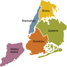
Brooklyn and Kings County
The borough of Brooklyn comprises the territory of Kings County. Until almost a century ago Kings County was least among the three original counties of Long Island, not only in area, but also in population. The population of Kings County was: In 1698, 2,013; in 1800, 5,740, and in 1840, 47,613. The increase was slow outside the limits of the two later cities of Williamsburg and Brooklyn. A description of the other towns within the county in the year 1700 closely fits the state of things in 1800. In 1700 the land was nearly all under cultivation; a century later some of the farms had been divided and the number of inhabitants had correspondingly increased.
During the first four decades of the nineteenth century the population rose more rapidly – from 5,740 in 1800, to 47,613 in 1840, yet this increase was mainly caused by the influx of people into Brooklyn and Williamsburg, where ropewalks and factories had been built. The other towns were still farming districts. Indian footpaths connected the shores of the East River and Jamaica Bay. They followed the line of least resistance through the flats or level lands, which had been the cornfields of the Indians for many years, and these flats the white men were eager to possess. Along one trail settlements were established which were known as The Ferry, Breukelen, Bedford, Midwout, and Nieuw Amersfoort. Along another trail the Boswijck and “het kruispad” settlements came into existence. At an early date several settlers bought lands from the Indians in Flatlands, Flatbush, and probably in Brooklyn.
When the riding was created, Gravesend was made the shire town of the West Riding. This community had been founded by Englishmen, and was the only town in the later Kings County with which the English government could transact official business in English speech. The other settlements carried on their legal affairs in the Dutch tongue. Breukelen, which was then named Brookland; Midwout, then called Flatbush; Nieuw Amersfoort, later called Flatlands; Boswijck and New Utrecht were therefore made a separate district under the appellation of the “Five Dutch Towns.” A register was commissioned by the Governor for this district to take the proofs of all documents, which were required to be recorded in the “Office of Records” in New York City, where certificates were issued with the seal of this office.
The Five Dutch Towns also constituted an ecclesiastical society, and joined in the support of their ministers until the collegiate system was abolished about the end of the eighteenth century. In 1840 the town of Williamsburg was separated from Bushwick and on January 1, 1852, the city of Williamsburg came into existence. In 1852 the town of New Lots was separated from Flatbush. On January 1, 1855, the cities of Brooklyn and Williamsburg and the town of Bushwick were consolidated and incorporated as the city of Brooklyn. In 1886 the town of New Lots was annexed to this union, followed in 1894 by the towns of Flatbush, Flatlands, New Utrecht, and Gravesend. On January 1, 1898, Brooklyn became a borough of the city of New York. In 1810 Brooklyn had a population of 4,402 and there were 400 houses, fifty to sixty ships docked annually at its wharves, and there were then six grain or tide mills, three magazines for storage of gunpowder, several distilleries, three ropewalks, one Episcopalian stone church, one Reformed Dutch stone church, one Methodist church, one poor house, two market houses, constructed of wood and situated in the open spaces near the old and new ferries. The one at the old ferry was established in 1673 and both were abolished in 1814.
The post office of Kings County was in this town, and was a principal point of concentration for all the stage and other roads on the island. There was one weekly newspaper. A drawbridge was at this time contemplated to connect Brooklyn with New York. In 1850 the population of Brooklyn had risen to 96,838. In 1810 the village of New Utrecht contained forty houses and the Reformed Dutch Church edifice. The taxable property was valued at $275,765; the population was then 907; in 1835, 1,027; in 1840, 1,283. Neighborhoods in this town were Bay Ridge, Fort Hamilton, and Bath on Gravesend Bay. The fortress known as Fort Hamilton was constructed during the years 1824-1832. Fort Lafayette was built upon Hendrick’s Bluff, 200 yards from the shore, in 1812, and was originally known as Fort Diamond. A few feet below the surface, at the Narrows, was found in 1837 more than a wagon load of Indian arrow heads.
Of the 7,000 acres of land in the original Gravesend, 3,500 were farm land, 300 woodland, and the balance salt meadows and a ridge of sand hills near the seashore. Directly opposite Gravesend, on the other side of Lower New York Bay, is the Navesink Highlands; along these highlands and the Navesink River the sand is of a reddish color, hence the name of Red Bank in the neighborhood. On the Long Island shore the sand is of a grayish color and this fact may have led the settlers to name the shore “Granuwezande” or Grauesand, as the name is often written in the old documents, i. e.,”Grayishsand.” The Dutch Church was organized in 1763 and a church edifice was erected, which was replaced by a second one in 1833, and this one again by a third in 1894. Shortly after the conquest the town was made the seat of justice, a courthouse was erected, and the Courts of Session of the West Riding were held there. In 1810 Gravesend village contained twenty houses, the Reformed Dutch Church and a schoolhouse. A lighthouse was designed to be erected at Coney Island. There were two tide mills. The taxable property was valued at $178,477. The population was 520, which rose to 810 in 1840. The settlement in Sheepshead Bay was originally known as “The Cove” and later as Sheepshead Bay. Other neighborhoods were Unionville and Guntherville, on Gravesend Bay, South Greenfield on the King’s Highway, and on the head of Gerrettsen’s Creek, extending over the Flatlands line.
Flatbush was originally known as Midwout and was first settled in 1651. In 1810 it was known as the capital of the county. The village then contained about 100 houses, standing on the town road and covering a stretch one and a half miles in length; the stone buildings of the Reformed Dutch Church, the courthouse and jail, Erasmus Hall Academy and two common schools, also two tide mills and one windmill, were within the town limits. The population was then 1,159, which rose to 2,099 in 1840. The poorhouse of the county was located in the town. Neighborhoods in the town were: Greenfield, Parkville, Oaklands, and Windsor Terrace.
Flushing was originally called Vlissingen, after a place in the Netherlands. The settlers erected a blockhouse near the pond at a point later known as Union Street and Broadway. Prior to 1821 the only road between Little Neck and Flushing Village was through what was later known as the “alley,” winding its way round about and over hills and increasing the distance more than two miles before reaching its terminus at the “lonely barn.” In 1824 the road from Little Neck Hotel was donated, a causeway constructed, and a ridge built at Wyandot Van Zandt’s expense, who owned the land. In 1824 the road was turnpike to Roslyn and three years later to Oyster Bay. It was known as the Flushing and North Hempstead Turnpike Road and later as Broadway. An Indian trail formerly existed there and in widening the road the Indian burying ground at Little Neck, where for two centuries the remains of the red men had rested, had to be cut off.
The Jamaica band of Indians dwelt upon the shores of Rockaway Inlet; the territory around Jamaica Bay was known as Conorasset, i. e., the planting land of the bears, or Canarsee tribe. When Queens County was created the courts were transferred from Hempstead to Jamaica Village and a County Court was erected. When the building became too small for its purposes and the stone meeting house had been erected, the courts were held for some years in that edifice. Later a new courthouse was erected and used until the seat of justice was removed to North Hempstead. Increase Carpenter’s Tavern, later known as Goetze’s Hotel, was used as a tavern from the date of 1710. The inn was the scene of General Woodhull’s capture. The property purchased by Rufus King, in 1805, consisted of a roomy house and of about ninety acres of land, situated a little west of the village on the main road. The town was several times the seat of the colonial legislatures.
College Point, formerly called Strattonport, is the northwestern portion of a tract of land which was known as Lawrence’s Neck, or Tew’s Neck. The neck was named after William Lawrence, who resided there. Eliphalet Stratton purchased, in 1790, 320 acres of land on the neck for 300 Pounds. About 1850 his daughter disposed of 140 acres, the site of the later village, for the sum of 30,000, retaining the balance of the land in the family. Here was located St. Paul’s College, an institution for the education of young men for the Episcopal ministry. The college was discontinued, but the name of College Point remained in use. Whitestone was settled nearly at as early date as that of Flushing. It was first named Cookie Hill, and its later name came from a large white rock that lies at the point where the tides of the Sound and the East River meet. There was the house of Francis Lewis, the only signer of the Declaration of Independence who resided in Queens County. During the popularity of DeWitt Clinton the place was known as Clintonville. At the beginning of the last century there were within the circumference of one mile only twelve houses in the village. About this time a ferry was in existence, running from this point to Throgg’s Neck, in Westchester County, mostly used for the conveyance of cattle. Bayside, three miles north of Flushing Village, was settled soon after Flushing. Dr. Rodman settled there; he died in 1731. The land at Douglass Point was owned by Thomas Hicks long before the Revolution.
After several changes the property passed into the hands of George Douglass, and so derived its name. In 1784 the town of Hempstead was divided into North Hempstead and South Hempstead. The mansion of George Duncan Ludlow, at Hempstead Plain, later called Hyde Park, was one of the largest houses in the island. The estate was confiscated in consequence of his adherence to the British side in the war. The courts of the colony were originally for the most part held at Hempstead.
